For someone who traditionally does not watch videos, I’ve been streaming my fair share lately: Some are mindless; some resonate. Of those that resonated, Coming Home – Ag Teacht Abhaile was a highlight. This trail running documentary follows Paddy O’Leary on his quest to complete the “self-navigated 115 kilometer Wicklow Round.”
One cool aspect of Ireland’s Wicklow Round is the reliance on old-school tech: A map and compass. Runners navigate up and over 26 Wicklow Mountain summits, climb roughly 20,000 feet over more than 62 miles of Irish burliness with no GPS crutch. Adding punch to the circuit, since it’s in Ireland, stalling for bluebird skies on your Wicklow Round attempt might be like waiting for an extra blue day in late March. During O’ Leary’s attempt at the FKT, many hours were spent immersed in low clouds and ground fog – line of sight travel became tricky.
For some of us during the last six or seven weeks, pouring over Google Earth or apps like TrailForks or CalTopo have provided some outdoor solace. With some mining, it’s possible to locate isolated forest roads or even old trails where social distancing is not a concern. You’ll likely be the only person around.
Even better, near cities like Bend, Ore. for example, with a bit of legwork, you can find places to run and bike in isolation. And east of Bend, where human settlements are rare between here and Boise, Idaho 320 miles away, linking together big running traverses on BLM and Forest Service land, with the occasional jaunt around private ranch land, remains possible.
Not all folks have big open country out the backdoor. It’s a luxury. But maybe in these times, we can all imagine our own version of the Wicklow Round. This brings basic map and compass navigation skills back into focus. Dreaming is one thing. Finding your way in the dreamscape is another. In other words, knowing how to reliably move from point A to B.
(Have kids at home? A map and compass can add some hands-on spiciness to the online school curriculum.)
With this in mind, we’re presenting some basics on navigating with a map and compass. Maybe keep the GPS capable smartphone handy just in case, but the tactile sensation of a map and compass coupled with overland travel might be just the remedy you’re looking for to feel out-there. (Remember, always tell someone about your intended route – every day is safety day.)
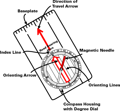
- Using and Map and Compass basics. After watching several how-tos, the first video posted below renders the basics into a few key points.
- Figure out two points on the map: where you are and where you want to go.
- Line the compass edge up with point A to point B. Spin compass dial to line up orienteering lines on the compass with the orienteering lines on the map.
- Determine bearing on the top of the compass.
- Hold the compass in front of you and turn slowly until the magnetic needle lines up with the orienteering arrow on the compass.
- Pick an object in your direction of travel, and walk.
In the video below from Mountaineering Ireland, many of the same basics are reviewed. This video does explore the concept of magnetic declination/magnetic variation and how to adjust your compass accordingly. This NOAA wesbite presents useful information about magnetic declination.
As always, we urge you to respect your local rules on recreating.
Jason Albert
Jason lives in Bend, Ore., and can often be seen chasing his two boys around town. He’s a self-proclaimed audio geek. That all started back in the early 1990s when he convinced a naive public radio editor he should report a story from Alaska’s, Ruth Gorge. Now, Jason’s common companion is his field-recording gear.


