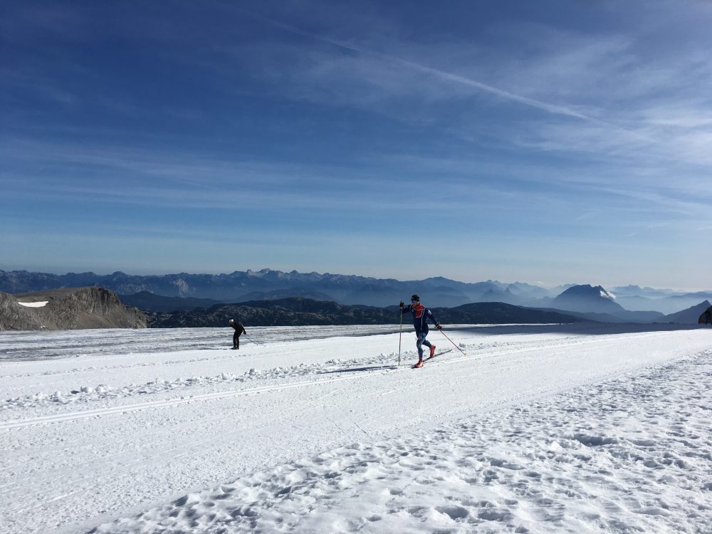
Ben Lustgarten (CGRP) striding out on the Dachstein Glacier. (Photo: courtesy Ben Lustgarten)
Sometimes off-season snow is an afterthought — access to trail running, mountain biking, and yes even rollerskiing is enough to satiate the training apatite. And sometimes it’s not. Warm temps prevent access to snow and maybe you simply need a break.
With that in mind, here are some resources for accessing snow in Ramsau am Dachstein: the famed high region in Austria where the Dachstein glacier awaits with groomed “off-season” cross-country tracks.
The basics to access snow are this: take toll road to gondola — gondola to the glacier — walk/hike a short distance to glacier skiing — ski. Reverse in order when descending to town.
Most tourist stay in or around Schladming, a small mountain town nestled in the valley with all the amenities you’d expect. Schladming is also at the base of the toll road.
Dates for Groomed Ski Tracks: Mid-May through the end of November. During the fall months, you are likely to see a smattering of World Cup skiers on locale testing skis and readying the fitness.
Travel to the Gondola: It’s a bit more complicated than simply hopping on an express chairlift and zipping to snow right from town. So let’s back up a bit. The gondola is accessed by a toll road. According to online info, the toll road fee is waived for those presenting a validated pass for the Dachstein gondola. We assume you are there to ski, so you’ll have a lift pass and therefore will not be paying to use the toll road. Otherwise, that’s a € 14.00 toll road fee with no valid lift pass. Local buses also offer transport up the toll road.
Gondola Service to and from the Glacier: Round trip on the gondola for an adult is € 39.00. (This does not include a cross-country ski pass. It’s only for the lift ride up and down.) The first lift up rolls at 7:50 AM. Make note, if you are traveling to the Dachstein during the summer, you are required to make a gondola reservation. “DURING SUMMER A GONDOLA RESERVATION IS REQUIRED!” All caps and an exclamation point claims the website– they mean business. The website we have linked claims reservations are needed until the beginning of September. Evidently, non-ski tourist love the high altitude access too.
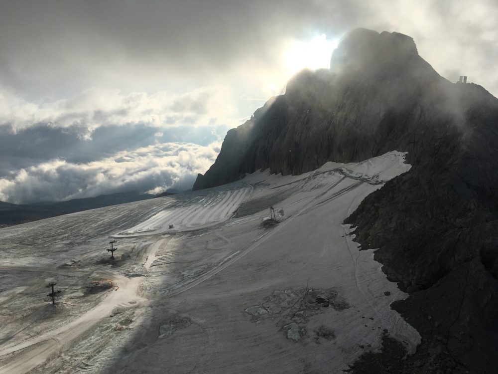
Some scale for reference. Groomed ski tracks on the Dachstein Glacier. (Photo: Ben Lustgarten)
The 18 kilometers of tracks are groomed for skate and classic. Depending on snow conditions, the available skiing may be less than 18 k.
Ben Lustgarten of the Craftsbury Green Racing Project (CGRP) has been in Ramsau am Dachstein with several teammates and had this advice:
The skiing this year is pretty good, but short. This is only my second time here but it is shorter than the previous time, and there are plenty of rocks and dirty snow/ice. I would recommend rock/training skis for sure. The temperature this time of year is around 25 Fahrenheit or when its sunny it can warm to 40 Fahrenheit. We aim to take the first gondola ride up that leaves the tram at 7:50 am so we ski at around 8:05 am for a few hours. Earlier is better because it only gets warmer and softer and skied in throughout the day.
So far we have been lucky and have had good weather. When it is sunny it is absolutely gorgeous. But it can be quite windy, foggy, cloudy, and rainy as well. I always pack a rain jacket, ski pants, ski jacket, buff, etc just in case because even if it is sunny at the bottom it can be totally different up there. Also remember sunscreen for your face and dark or photochromatic sunglasses. Even if it is cloudy, there’s a ton of UV reflection on the glacier. I would recommend boot covers that brands such as Alpina, Rossi, and Fischer have now because you have to walk down a steep rocky section that can very easily destroy carbon ski boots, or bring running shoes to use for that section. As always, plan to pack dry clothes and a snack for after, because if you miss the gondola down it is a 20 min wait then a 10min gondola ride down and you don’t want to mess up your recovery especially when you are training at 10,000 ft.
There is not a table and bench waxing set up at the glacier. For skate skiing I recommend waxing, scraping, and brushing your skis before you get to the gondola so you are ready to go when you get up there. For classic I think we were kicking on some universal klister. But if you want to ski for a while bring the tube with you because there are lots of icy corners and you will inevitably scrape off your kick within an hour or so.
We have been cooking all of our meals, so can’t comment on local food, but I am sure it is awesome! There is an extensive grocery store in Schladming as well.
Below are some visuals to help orient yourself with the splendors of the Dachstein. (Click images to enlarge.)
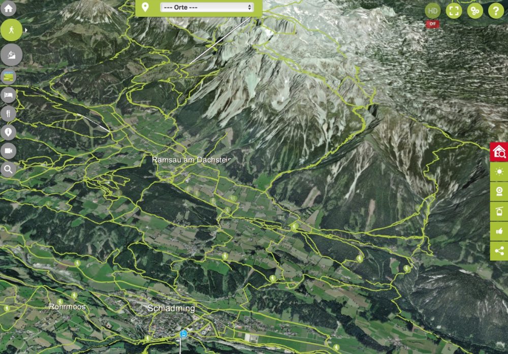
A zoomed out view showing Schladming and the cross-country tracks to the right of the Dachstein Skywalk towards the mountain shadows.
Map from derdachstein.at
The Mountain Running:
The area also offers world-class dryland training. Much of it in the form of mountain running.
Caitlin Patterson of the U.S. Ski Team and the CGRP relayed that many of the local accommodations offer a complimentary “Summercard”. The card provides access to free bus service and discounted entry to several local attractions.
Patterson is also an accomplished mountain runner. Here’s her advice on using some phone apps to assist with determining the day’s running route.
3d map screenshot
There are a lot of great trails meandering around the valley and lower hills near Ramsau, but what I really like to do is get up higher in the mountains! The visitor/information center in Ramsau has paper maps which are quite helpful, with the trails numbered as they will be out on the signs, but there are also plenty of resources online. I like to use the “Offline Topo Maps” app, where I can download a map of this area, since I don’t have European cell service. I also just discovered this 3D interactive map, which could be useful to give newcomers a sense of the vertical: https://www.schladming-dachstein.at/en/service/digital-services/3d-realitymap-webgl
Generally this year I’ve been cross-referencing several of these maps, studying my route, and then also programming it into my Suunto 9 watch using the Suunto App which is extremely handy for mileage estimations and on-the-fly navigation.
A few notes for people going for any of the serious mountain/trail runs:
1. Don’t calculate mileage based on your flat-running speed – the mid-to-high mountain trails are rocky and climb a lot. We pro skiers are finding that at a pretty good clip we cover about 4 miles per hour in these mountains, sometimes a little less. For example a 9.5 mile run/hike the other day took 2.5 hours.
2. All major trails are directed with yellow signs, which have trails labeled with their numbers, and the destinations and time estimate to those destinations. Related to the speed of travel note above, we find that we can run/hike in about 1/2 the time marked on the sign. Not like in the U.S. where you can divide a hiker time estimate by 4 or 5 – people hike fast here! Most of the trails also have painted markers on rocks guiding along the way.
3. If the weather is bad or foggy, consider staying down lower or at least don’t venture onto steep unknown trails if you can help it – there are quite a few via ferrata routes around here that are awesome but not to be taken lightly nor without gear. This is part of the reason to cross-reference several maps when planning a route, and pay attention to the ladder symbols or other mentions of via ferrata or klettersteig.
4. If visitors are into adventure and don’t mind heights, the via ferrata (German name kletterstieg) is really fun, a kind of hybrid of rock climbing and hiking with metal cables and pins. You can find guidebooks in the info center, and can rent or buy gear at local shops like Ski Willy.
5. Carry a few Euros so you can grab a snack at the huts, or sometimes you may also need to pay to refill water at the huts.
A few of my very favorite runs/hikes:
– hike up from Ramsau to the Guttenberghaus. Guttenberghaus up and down is about 7.5 miles, expect 2-3 hours. Can add on one of several peaks up above the hut.
– link a loop by ascending the Silberkaralm Gorge east of town, across the top/back of the ridge, and down the Guttenberghaus trail. Silberkaralm Gorge to Guttenberghaus and down, 10.8 mile loop so expect 3-4 hours.
– hike to top of Rettenstein, west of Ramsau. 6-10 mi depending on start and end point.
– from tram base station, make a loop to the west that goes through a pass between “Raucheck” and “Torstein”. We present you the gaming portal 1xbet live India, you will find interesting slots, a large number of sports events. This is 9 miles from base of tram, several miles longer if running from town. On the 3D map this loop is called “Torwanderug”
There is also quite a good rollerski track, but it would be recommended only for advanced rollerskiers because it has some serious corners and descents. In general for intensity, we’ve done running with poles intervals down in town, to keep the speed sharp after a bunch of glacier skiing.